Antarctica’s highest mountain
At 4,892 metres (16,050 ft) Mount Vinson is the highest peak in Antarctica. It was only discovered in 1958 when a US Navy plane spotted it.
That might seem strange that it was discovered so late but at that time much of Antarctica had still not been explored and it is also part of the Vinson Massif which is 21 km (13 mi) long and 13 km (8.1 mi) wide and has plenty of mountains. So it was easy to get lost amongst them.
Hollister Peak, for instance, is only 2 km away from Mount Vinson and is nearly as high at 4,729 metres (15,515 ft). Mount Tyree (4852m) is the second highest mountain of Antarctica and is located 13 kilometres northwest of Mt Vinson.
Mount Vinson is named for U.S. Rep. Carl Vinson of Georgia, who served in Congress from 1935 to 1961 and was the former chairman of the House Armed Services Committee. He was a champion of government funding for American exploration of Antarctica.
All eleven members of the American Antarctic Mountaineering Expedition 1966/67 were the first to successfully climb the mountain and since then over 1400 people have managed the ascent.
Mt Vinson is part of the seven summits challenge. A goal of many mountaineers is to climb the highest peak on each of the seven continents. Mt Vinson is the most remote of all the peaks.
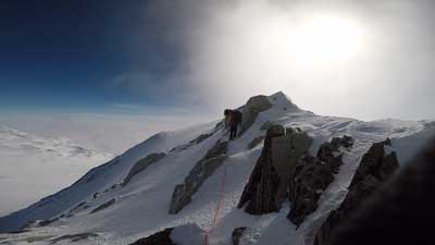
It is not a technically difficult climb but that doesn’t mean it’s easy. It takes about 10 days to reach the summit and the cold, windy conditions mean that not everyone reaches the top.
You can go climb it yourself if you have a spare $30,000 -$45,000 for a guided expedition which will get you from Chile to Antarctica and a guide to take you up.
This video gives you an idea of what the area looks like: